One of the most important roles of city government is centered on how land in the city is planned to be used. This planning happens by zoning different areas of town for different uses. The City has several zone types, including:
- R-1 Single-Family Residential – Typically this is a standalone single-family home and as with other residentially-zoned properties, may include an accessory dwelling unit (ADU)
- R-2 Medium Density Residential – Depending on the size, on some lots there may be two or three homes on the lot
- R-M Multiple-Family Residential – Typically this would be condominiums, apartments or a group of small homes
- C-3 General Commercial – This would be an office building, restaurants and retail and service businesses
- C-M Commercial-Manufacturing – This could be retail with fabrication, a restaurant, and office uses
- M-1 Light Manufacturing – Typically this is some form of minor fabrication, warehousing, or wholesale sales
- M-2 Heavy Manufacturing – Heavy manufacturing could include more intense fabrication or warehousing and wholesale
- PD-PS Planned Development with Performance Standards – This special category can result in a mix of residential, commercial, and industrial uses that address site specific issues
When Paramount incorporated in 1957, the City inherited land uses that the County of Los Angeles had put in place. The City Council adopted a new Zoning Ordinance and Zoning Map in 1962. Though changes have been made over the years, that basic blueprint resulted in much of the zoning that exists today. Even if an area is re-zoned, however, the City cannot force a business to close or re-locate. Indeed, many of the industrial uses in town predate the City’s incorporation.
The following timelines provides a good history on the land use history of the City.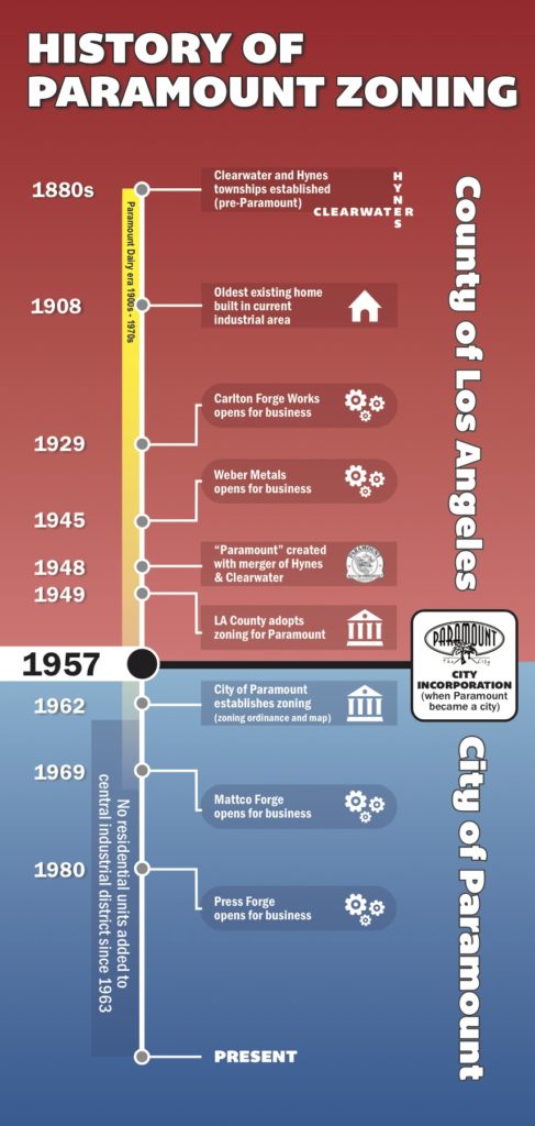
Finally, here is today’s current zoning plan map.

In reference to the map above, the land-use percentages of Paramount are as follows:
- Residential: 53%
- Commercial: 5%
- Industrial: 27%
- Public/Quasi Public: 15%
